
فائل:China Xinjiang Ili.svg

Size of this PNG preview of this SVG file: ۷۰۵ × ۵۹۹ پکسلز. دوجے ریزولوشنز: ۲۸۲ × ۲۴۰ پکسلز | ۵۶۵ × ۴۸۰ پکسلز | ۹۰۴ × ۷۶۸ پکسلز | ۱,۲۰۵ × ۱,۰۲۴ پکسلز | ۲,۴۰۹ × ۲,۰۴۸ پکسلز | ۱,۰۰۰ × ۸۵۰ پکسلز ۔
اصل فائل (ایس وی جی فائل، پکسل:۱,۰۰۰ × ۸۵۰، فائل سائز: ۲۳۳ کلوبائٹ)
| تفصیل |
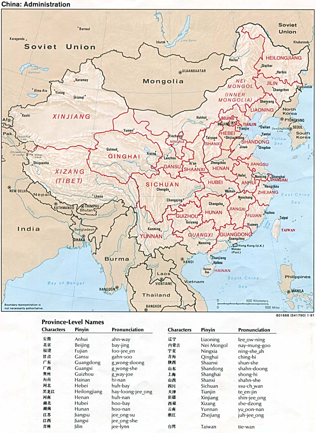
An SVG map of China with Xinjiang highlighted in orange and Ili Prefecture highlighted in red Legend: |
||
| تریخ | |||
| سروت |
self-made; based on CIA public domain maps:
and Wikimedia Commons work: |
||
| لکھاری | Joowwww | ||
| اجازت (فائل نوں دوبارہ ورتنا) |
|
||
| دوجے ورژن |
Derivative works of this file: Second ETR in China.svg
|
||
| SVG genesis |


فائل دی تریخ
فائل نو اس ویلے دی حالت وچ ویکھن واسطے تاریخ/ویلے تے کلک کرو۔
| تریخ تے ویلہ | نکی مورت | پاسے | ورتن والا | تیپّݨی کرو | |
|---|---|---|---|---|---|
| موجودہ | ۱۹:۵۰, ۱۲ فروری ۲۰۱۰ | | ۱,۰۰۰ × ۸۵۰ (۲۳۳ کلوبائٹ) | Joowwww | {{Information |Description=An SVG map of China with Xinjiang highlighted in orange and Ili Prefecture highlighted in red Legend:<br />File:China map legend.png |Source=self-made; based on CIA public domain maps: *http://www.lib.utexas.edu/maps/middl |
فائل دی ورتوں
تھلے دتے گئے 1 صفحے اس فائل نال جُڑدے نیں
فائل ویاپک ورتوں
ایہہ دوجے وکیاں ایس فائل نوں ورتدے نیں –
- ar.wikipedia.org تے ورتوں
- ca.wikipedia.org تے ورتوں
- cdo.wikipedia.org تے ورتوں
- ceb.wikipedia.org تے ورتوں
- da.wikipedia.org تے ورتوں
- en.wikipedia.org تے ورتوں
- es.wikipedia.org تے ورتوں
- eu.wikipedia.org تے ورتوں
- fa.wikipedia.org تے ورتوں
- fi.wikipedia.org تے ورتوں
- fr.wikipedia.org تے ورتوں
- gl.wikipedia.org تے ورتوں
- id.wikipedia.org تے ورتوں
- incubator.wikimedia.org تے ورتوں
- kk.wikipedia.org تے ورتوں
- lt.wikipedia.org تے ورتوں
- nl.wikipedia.org تے ورتوں
- os.wikipedia.org تے ورتوں
- pt.wikipedia.org تے ورتوں
- ru.wikipedia.org تے ورتوں
- th.wikipedia.org تے ورتوں
- tt.wikipedia.org تے ورتوں
- ug.wikipedia.org تے ورتوں
- uk.wikipedia.org تے ورتوں
- ur.wikipedia.org تے ورتوں
- uz.wikipedia.org تے ورتوں
- vi.wikipedia.org تے ورتوں
ایس فائل دا ویکھو ہور جگت ورتن .