
فائل:North ossetia alania map.png

ایس وکھالے دا ناپ: ۵۳۴ × ۵۹۹ پکسلز۔ دوجے ریزولوشنز: ۲۱۴ × ۲۴۰ پکسلز | ۴۲۸ × ۴۸۰ پکسلز | ۷۲۰ × ۸۰۸ پکسلز ۔
اصل فائل (۷۲۰ × ۸۰۸ پکسلز, فائل حجم: ۵۳ کلوبائٹ, MIME type: image/png)
خلاصہ
| تفصیل |
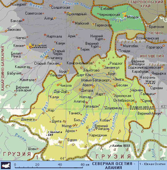
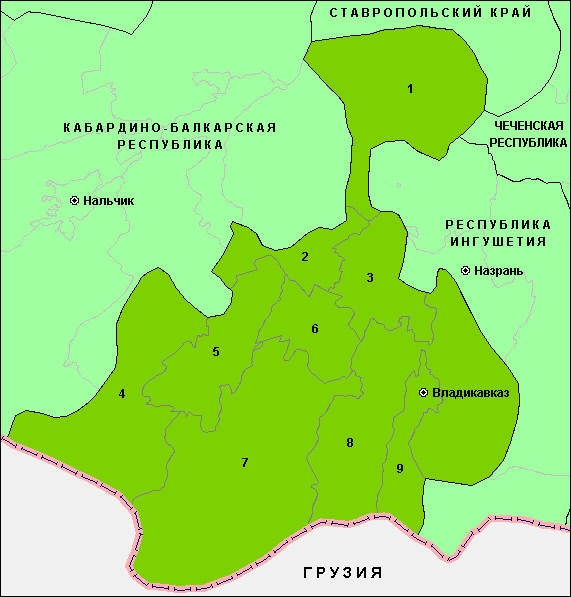
English: Map of the Republic of North Ossetia-Alania. |
| تریخ | |
| سروت | آپݨا کم |
| لکھاری | PANONIAN |
لائسنس –
میں، اس کم دے کاپیرائٹ دا مالک، اس کم نوں اس لائسنس دے مطابق چھاپدا واں:
| ایس فائل نوں ایہ لسنس کریٹو کامنز CC0 1.0 یونیورسل پبلک ڈومین ڈیڈیکیشن دتا گیا اے۔ | |
| اوہ بندا جینے اے کم کیتا اے اونے اے کم public domain دے ناں لایا اے تے سارے حقاں نوں چھڈ دتا اے۔ تسیں اینو کاروبار کم لئی ورت سکدے اے یا بدل سکدے او بنا کسے اجازت دے۔
|
References
Maps from external links:
- http://www.skppk.ru/i/map/osetiya_region_map.jpg
- http://ossetians.com/pictures/Map_1.jpg
- http://topwar.ru/uploads/posts/2011-06/1309189225_alania_karta.jpg
- http://www.stopwatchhut.com/places/770.jpg
- http://nocss.ru/projects/10/images/map-1.jpg
- http://karty.narod.ru/maps/sosetia/s-osetia.GIF
- http://obkom.com/russia/fussr/osetiya-yuzhnaya/images/karta-osetia-sev-yuzh.jpg
- http://karta-russia.ru/maps/map-severnaya-osetiya-karta.jpg
- http://alcoinf.com/images/severnaya-osetiya.gif
- http://sif.ru/images/maps/Severnaya-Osetiya2.gif
- http://region15.ru/img/territor/map-adm.gif
- http://www.hge.pu.ru/mapgis/subekt/osetia/osetia.gif
- http://www.smsr-senclub.ru/upload/medialibrary/ece/ece341c19c79030e09063fff6763d2d5.jpg
- http://www.rossadovod.ru/regions/osetia-alania/map.jpg
- http://www.ntsomz.ru/img/severnaya%20osetiya_800x566.jpg
- http://trasa.ru/img/regions/sevosetiya.gif
- http://dic.academic.ru/pictures/enc_geo/Severnaya_Osetia-Alania.jpg
- http://geo.1september.ru/2008/22/40-1.jpg
- http://openbudget.karelia.ru/budnord/russian/north-caucasian/northern-ossetiya-republic/images/karta_alania.jpg
List of largest cities and towns:

|
This map image could be re-created using vector graphics as an SVG file. This has several advantages; see Commons:Media for cleanup for more information. If an SVG form of this image is available, please upload it and afterwards replace this template with
{{vector version available|new image name}}.
It is recommended to name the SVG file “North ossetia alania map.svg”—then the template Vector version available (or Vva) does not need the new image name parameter. |
فائل دی تریخ
فائل نو اس ویلے دی حالت وچ ویکھن واسطے تاریخ/ویلے تے کلک کرو۔
| تریخ تے ویلہ | نکی مورت | پاسے | ورتن والا | تیپّݨی کرو | |
|---|---|---|---|---|---|
| موجودہ | ۱۱:۵۱, ۱۷ جون ۲۰۱۲ | | ۷۲۰ × ۸۰۸ (۵۳ کلوبائٹ) | PANONIAN | {{Information |Description ={{en|1=Map of the Republic of North Ossetia-Alania.}} |Source ={{own}} |Author =PANONIAN |Date =2012 |Permission = |other_versions = }} |
فائل دی ورتوں
تھلے دتے گئے 1 صفحے اس فائل نال جُڑدے نیں
فائل ویاپک ورتوں
ایہہ دوجے وکیاں ایس فائل نوں ورتدے نیں –
- ace.wikipedia.org تے ورتوں
- ast.wikipedia.org تے ورتوں
- az.wikipedia.org تے ورتوں
- ba.wikipedia.org تے ورتوں
- be-tarask.wikipedia.org تے ورتوں
- be.wikipedia.org تے ورتوں
- bg.wikipedia.org تے ورتوں
- br.wikipedia.org تے ورتوں
- bs.wikipedia.org تے ورتوں
- bxr.wikipedia.org تے ورتوں
- ce.wikipedia.org تے ورتوں
- cs.wikipedia.org تے ورتوں
- cv.wikipedia.org تے ورتوں
- diq.wikipedia.org تے ورتوں
- en.wikipedia.org تے ورتوں
- es.wikipedia.org تے ورتوں
- et.wikipedia.org تے ورتوں
- eu.wikipedia.org تے ورتوں
- fo.wikipedia.org تے ورتوں
- ga.wikipedia.org تے ورتوں
- gl.wikipedia.org تے ورتوں
- got.wikipedia.org تے ورتوں
- hy.wikipedia.org تے ورتوں
- id.wikipedia.org تے ورتوں
- is.wikipedia.org تے ورتوں
- it.wikipedia.org تے ورتوں
- ka.wikipedia.org تے ورتوں
- kbd.wikipedia.org تے ورتوں
- koi.wikipedia.org تے ورتوں
- krc.wikipedia.org تے ورتوں
- kv.wikipedia.org تے ورتوں
- la.wikipedia.org تے ورتوں
- lbe.wikipedia.org تے ورتوں
- lmo.wikipedia.org تے ورتوں
- lt.wikipedia.org تے ورتوں
- mhr.wikipedia.org تے ورتوں
- mn.wikipedia.org تے ورتوں
- mr.wikipedia.org تے ورتوں
- ms.wikipedia.org تے ورتوں
- myv.wikipedia.org تے ورتوں
- nn.wikipedia.org تے ورتوں
- ps.wikipedia.org تے ورتوں
- ro.wikipedia.org تے ورتوں
- rw.wikipedia.org تے ورتوں
- sah.wikipedia.org تے ورتوں
- scn.wikipedia.org تے ورتوں
- sco.wikipedia.org تے ورتوں
- se.wikipedia.org تے ورتوں
- simple.wikipedia.org تے ورتوں
ایس فائل دا ویکھو ہور جگت ورتن .